Introduction – On Peakbagging and Highpointing
I think it’s fair to say that any peakbagger who pursues a list of mountains develops a certain attachment to his/her pet project over a period of time. I certainly had such feelings in the 90s as I found myself chasing various Northeastern U.S. mountain lists. One by one, I completed these mostly elevation driven lists, and one by one, I experienced a certain euphoria followed by an inevitable letdown at no longer having the objective on which to focus my efforts. It was done and while I certainly felt a sense of accomplishment, I soon found myself looking for a new project. After several cycles of this, I eventually started looking for a more substantial goal; something that would define my outdoors pursuits not for a year or two but perhaps for a decade or two.

2001 : Enter state highpointing. Yeah, I know the criticisms. Mount Sunflower, Britton Hill, Ebright Azimuth. I’ve heard and read it all before. How can this list be considered a serious objective when it includes a bunch of non-mountains? I guess the short answer is that this hobby is as much about exploring and expanding one’s personal boundaries as it is about mountaineering. For more than eight years now, I have pursued state highpoints and have found no list more personally satisfying. I’ve had the pleasure of the company of my father on 17 highpoints, hiked with a handful of Summit Post members and systematically worked my way from coast to coast. This pursuit has become part of my identity. Family and friends alike inquire as to my progress and next mountain adventure. The entire experience has been extremely fulfilling and as I find the number of remaining state highpoints dwindling to a precious handful, I am starting to look back as much as I look ahead. I want to finish and yet I don’t want it to be over.
With these thoughts bouncing around in my head, I boarded US Airways flight 3897 in Albany, NY on the morning of September 21st bound for Hawaii and California and hopefully the completion of my 44th and 45th state highpoints.
Mauna Kea, Hawaii: September 22nd-23rd, 2009
After perhaps the longest day of travel of my life, I arrived at my hotel in Kona on the Big Island of Hawaii in the late night hours of September 21st. During my 24 hours of transit, including a 7-hour layover in San Francisco, I had managed to catch a few catnaps as well as read more than half of Dan Brown’s latest novel, The Lost Symbol. It had been a long day indeed but I was in Hawaii for the first time in my 40 years on this earth and felt very excited about scouting out Mauna Kea the next day for my planned hike on the 23rd.
Mauna Kea, believe it or not, is the tallest mountain in the world. A true but inactive volcano, its base is beween 19,000 and 20,000 feet below sea level. Add that onto its 13,796-foot peak elevation and you have a 33,476-foot base-to-summit span. Having said that, there is a road that goes all the way to the top so really anyone who so chooses can touch the roof of Hawaii.
For my hike, I chose to start at the Onizuka Visitor Center at the 9,200-foot level, leaving me a healthy hike of about 4,600 vertical feet to the summit. As I found out on the 22nd, the main Mauna Kea trail (AKA the Humu’ula trail) is very lightly used and has loose gravelly footing as a result of the volcanic rock. I spent most of the day on the 22nd acclimating and reading some more Dan Brown. A brief acclimatization hike of about 1,000 vertical feet woke up my lungs and gave me a feel for what lay ahead the next day.


At 6:30 AM on the 23rd, I was back at the Visitor Center and ready to go. The forecast was nearly perfect with mostly sunny skies predicted and just a chance of a late day shower. I lathered up with SPF 30 and had plenty of Gatorade with me (four liters) as I was fully prepared for a very warm day traveling across terrain that offered zero protection from the sun.
I can’t say that I felt strong right out of the gate. In fact, the feeling was quite the opposite. I had taken a few doses of Diamox by this point in the trip, but my body wasn’t yet completely adjusted to the altitude as I live near sea level. By the time I reached 10,500 feet, I was already weakening. Not good, I pondered. The road was still in sight and the temptation to “just drive it” loomed large in my thoughts. But I fought this off and pushed to 11,000 feet for a rest. Ahead, I could see the grades moderated and the footing improved. I guzzled a full liter and suddenly felt rejuvenated. Just like that. And from that point forward, I seemed to get progressively stronger as I worked my way through the contours.


The landscape up there on Mauna Kea is surreal. Giant cinder cones and craters give it an other-worldly feel. All I could think of was that it was a combination of the moon (for the terrain) and Mars (for the reddish hue). The upper elevations of Mauna Kea and its many sub-summits started to come into view after nearly three hours as any lingering doubts I had melted away in the late morning sun. One of the treats past the 13K mark is a short side trail to Lake Wai’au. Though only 10 feet deep, it is quite an unexpected sight so high on a volcanic peak. Apparently, it is fed by permafrost and snow meltwater and never goes dry. At 13,020 feet, it is reportedly the third highest lake anywhere in the US.

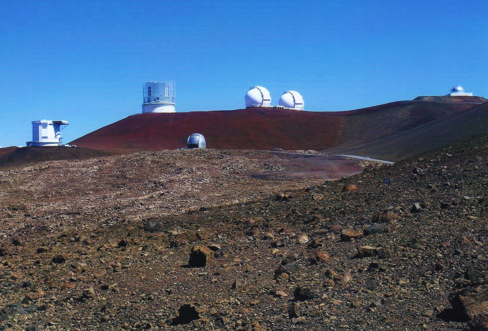
Shortly after the side trail to the lake, Millimeter Valley and its many telescopes came into focus. Though the highest point in Hawaii, Mauna Kea is probably more well-known as home to some of the best stargazing in the world. The interspersed facilities on such an odd landscape felt like something straight out of Star Wars. Soon the trail met the road and the final 1.4 miles to the top was primarily on pavement although reaching the true summit required you to leave the road once more for a short stroll to the USGS marker and summit cairn atop Pu’u Wekiu. It was a wonderful day on the zenith of Hawaii and I lingered for 30-45 minutes, snapping pictures and breathing the thinner air before returning to the Visitor Center via a longish road walk. Altogether, the 15-mile round trip took me eight hours and I was thrilled to have reached state highpoint #44.


Mount Whitney, California: September 26th-27th, 2009
More than any of the other state highpoints I’ve climbed, Mount Whitney required a lot of planning. As the highest point in the lower 48, this peak is extremely popular and offers many options for ascent. Anyone who has ever gone through the Whitney lottery process knows that obtaining a day or overnight permit is as valuable as a “golden ticket” from the classic Willy Wonka movie. For me, the process started in January and was a combination of applying for the permit, coordinating with co-workers to ensure I’d be able to take vacation on the days in question and reaching out to two highpointing Summit Post members with whom I’d previously hiked and who both “needed” Whitney. One of the Summit Post members wavered as to whether he would be able to go and this left Tom and me on the application for a three-day permit from September 26th to 28th (our first choice).
Without getting too heavily into all of the details … in the end, it all worked out logistically. So with permit reservation in hand, Tom and I spent many months corresponding about our planned Whitney hike via the mail trail. Tom’s plan was to spend some time visiting National Parks in California while I was out in Hawaii. We would meet up on the day before or the day of the hike and go from there. All seemed good until suddenly Tom’s luck went sour. First, he hurt his foot while hiking in the Adirondacks only a week before the trip and then – once in California – he wrecked his rental car, injuring his shoulder in the process. Just like that, Tom was out for a summit attempt. I had no problems with the idea of going alone, as I frequently solo, but sympathized with Tom over his lost opportunity after so many months of planning. In the end Tom did decide to hike up to Outpost Camp with me on Day 1 before turning back, so it wasn’t a complete loss for him.
In any event, I arrived in Lone Pine during the late afternoon of September 25th, secured the actual permit from the Eastern Sierra Interagency Visitor Center and checked into the Dow Villa Motel for the night. After a hearty breakfast at the High Sierra Cafe the next morning, I made my way toward Whitney Portal for an 11 AM meet-up with Tom. After the better part of a year planning this hike, it felt great to finally get on the trail!


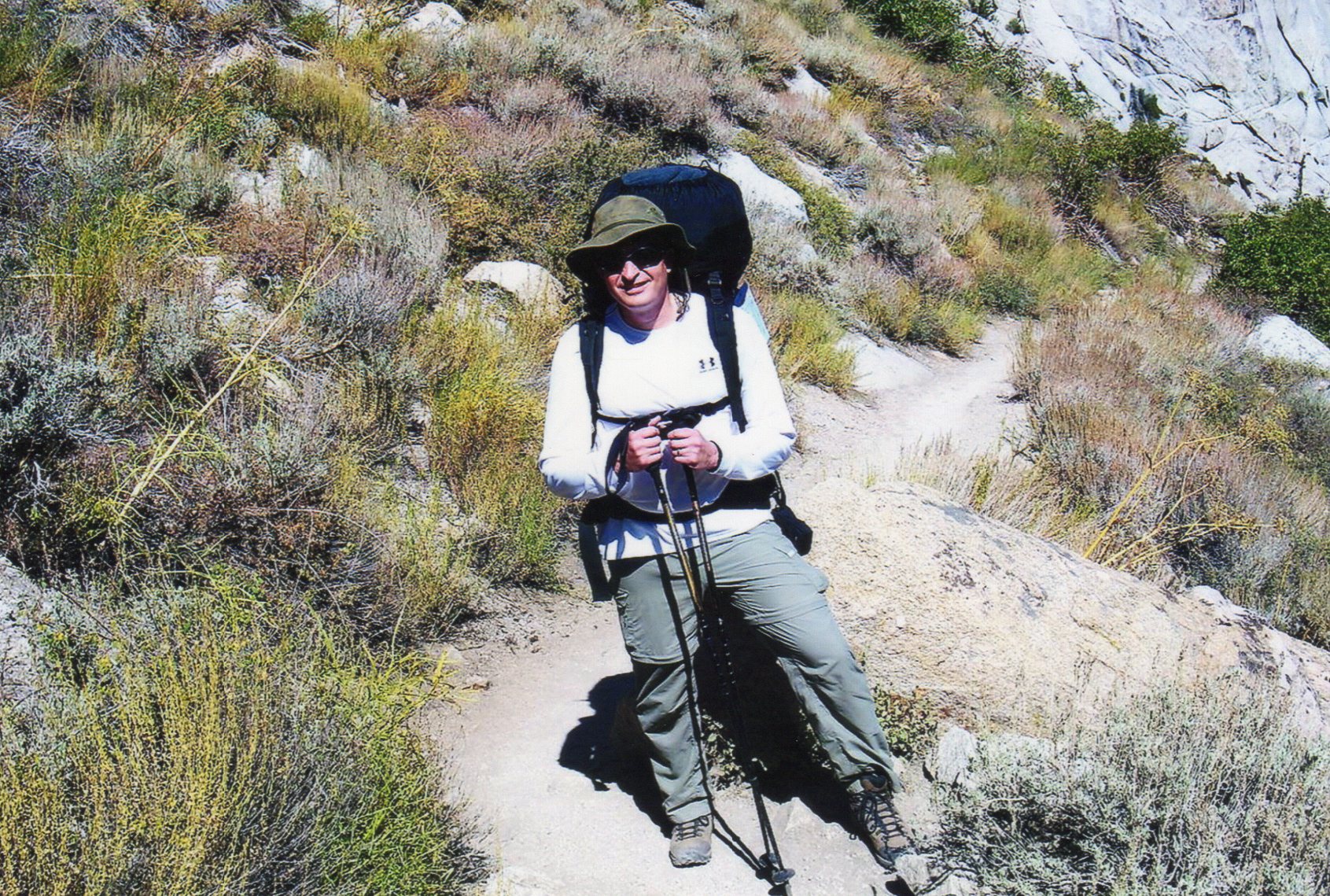
It didn’t take long to see why this mountain is so popular. Every step was a treat and the scenery was simply spectacular. For my first day’s objective, I planned to simply hike in 3.5 miles to Outpost Camp, putting 2,000 feet of the 6,750-foot total under my feet. My pace was slow to moderate and I took a few breaks simply to linger. Unlike my Mauna Kea hike (where I had the trail all to myself), there was no shortage of trailside small-talk to be found. Whitney is not only special, but very social as well.
By early afternoon, I reached Outpost Camp at the 10,300-foot level and Tom headed back down. I had plenty of time to move up to Trail Camp at 12,000 feet, but stuck with the lower camp knowing that I’m a strong hiker but have had altitude issues in the past. Sleeping lower – even if it meant a longer summit day – seemed to be my best move. So for the rest of Day 1, I simply soaked in the scenery and prepared for the following day’s summit attempt.


I can’t say I had a particularly restful night’s sleep. Between the excitement of the next day’s agenda and the steady stream of hikers that started tramping through camp in the wee hours of the morning, it was more an exercise in laying with my eyes closed than actual sleep. By the time 5:30 AM rolled around, I had decided to get an early start and joined the throng of night walkers, doing the first hour of my hike in the dark.
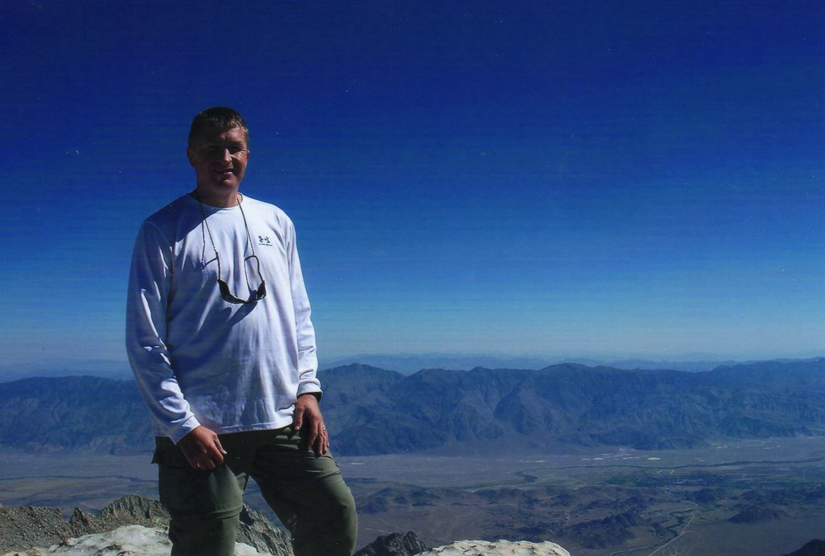
Once the sun started to rise, I once again found myself in awe of nature’s cathedral on this Sunday morning. Unlike the first part of my Mauna Kea hike, I felt great right from the start and passed many of the same people who had walked past my tent in the middle of the night. It became quickly obvious that many of the folks on the trail had little chance of summiting. I eagerly snapped pictures at every chance and topped off all of my water bottles just below Trail Camp. Before long, I made my way through the high camp and started up Whitney’s famed 97 switchbacks. The switchbacks were both fun and painless although I didn’t take time to count them. I quickly rose above Trail Camp and kept a constant eye on my altimeter and watch. Thanks to a misprint on Peter Croft’s Whitney guidebook, I was anticipating reaching Trail Crest at the 13,000-foot elevation mark. When I passed 13K with the ridge still far above, I started scratching my head. My altimeter had been accurate back at camp and the weather (and thus the barometric pressure) hadn’t changed. Hmmm. Well, of course, as it turns out, Trail Crest is really at 13,600’ and once I figured this out, I was very happy as I knew that I had less than 1,000 more vertical on Class 1 terrain to attain the summit. In short, I felt I now had it in the bag.


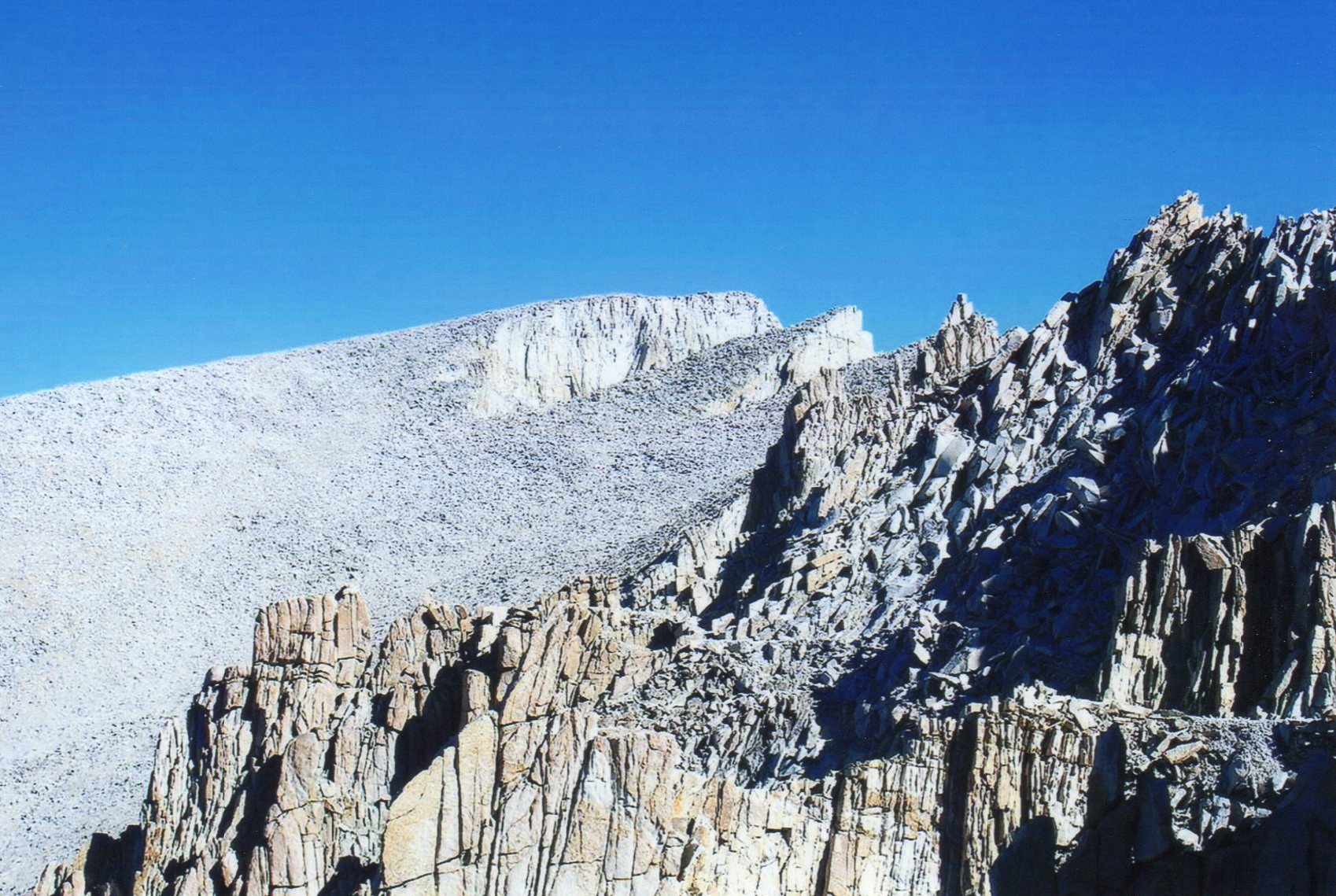
 Without a doubt, the best part of the hike for me came when I broke out onto the other side of the pass on the backside of the Needles and a whole new world opened up. The route to the summit became obvious and I thoroughly enjoyed “the windows” and the awesome views they offered.


Cheerful hikers on the way down soon started to offer encouragement as we passed one another in opposite directions. I closed to within less than a mile of the top and my excitement built. Finally, I saw it … Whitney’s famed stone summit shelter. I had done it. This mountain and the thought of this moment had been in my thoughts for years! The satisfaction was intense and the views were incredible. What more can you say?

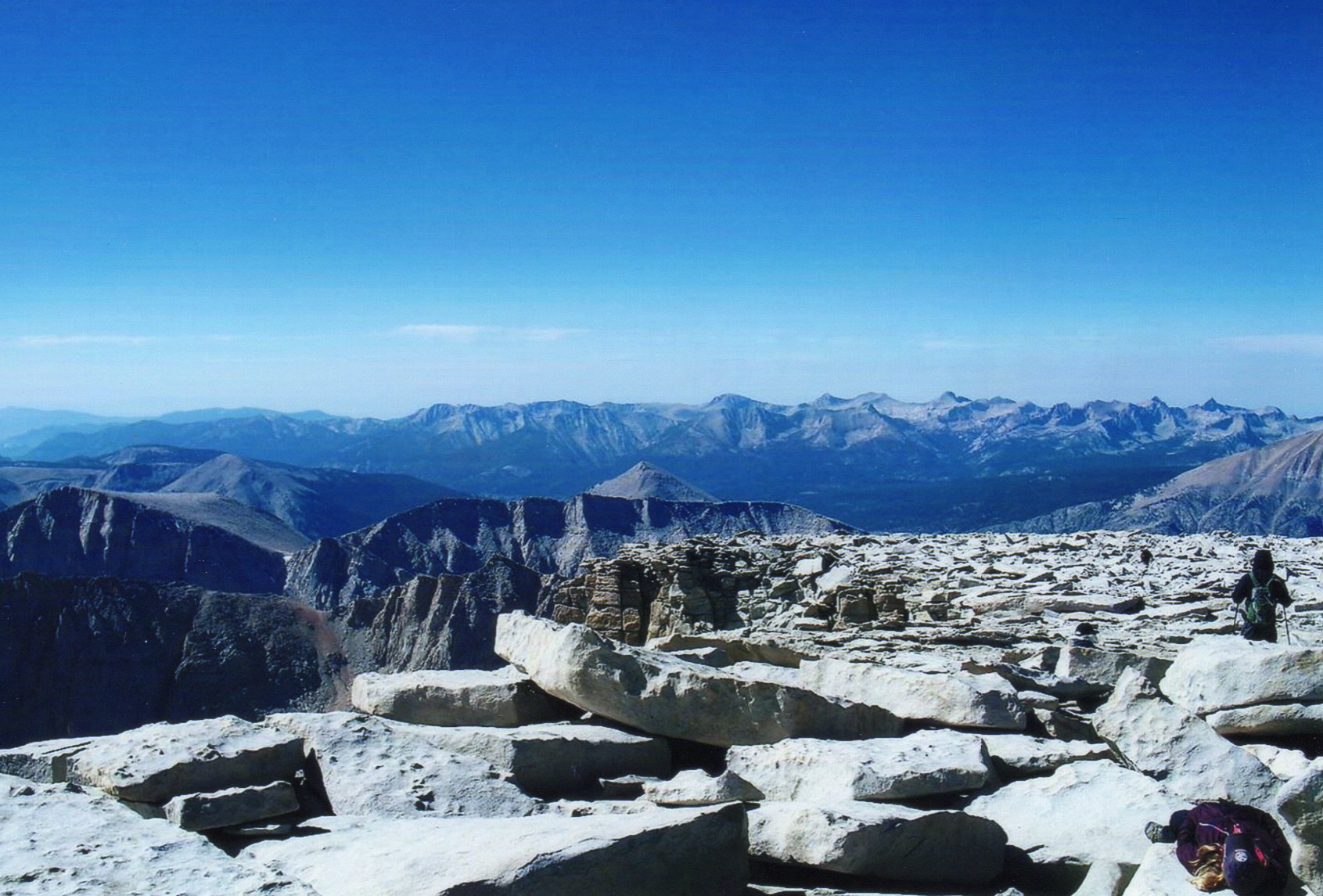

All told, it had taken less than six hours from camp to the summit. As it turned out, I would be back at my tent early enough to pack out. Nothing against Outpost Camp, but I wasn’t interested in another sleepless night. The rest of my travel went smoothly and I caught my plane home out of San Francisco early on the 29th. Every year, it seems, I characterize my trip out west as “the best week of hiking ever.” Well, once again, the agenda for 2009 has earned this distinction.
45 state highpoints down and five tough ones to go! Until next year …