Okay, so I’ll admit I knew the week was going to be a grunt. On the menu for this trip were two big western State Highpoints, each featuring more than 5,000 feet of elevation gain. Borah Peak, Idaho compacts that vertical gain into just 3.5 miles one-way while Kings Peak, Utah draws you deep into the High Uintas Wilderness before allowing you to ascend her slopes. It is a fairly regular one-two punch for State Highpointers but it is a nonetheless difficult agenda when one takes into account things such as Kings’ unpredictable weather, Borah’s famed Chicken-Out-Ridge and just a whole bunch of mileage and elevation gain compacted into a less than one-week period. Physically, I felt up to the challenge but those unknown X-factors that go into climbing mountains left me feeling like I would need a little bit of luck on my side to bag my 42nd and 43rd highpoints. So instead of going into this trip with a bad case of summit fever, I decided to focus on enjoying myself and getting the most out of the experience in these fine mountain ranges.
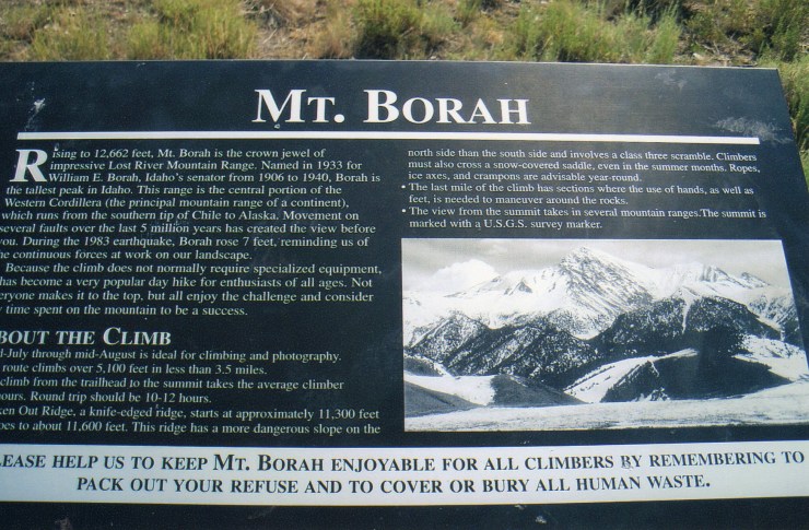
Mount Borah, Idaho – Lost River Range
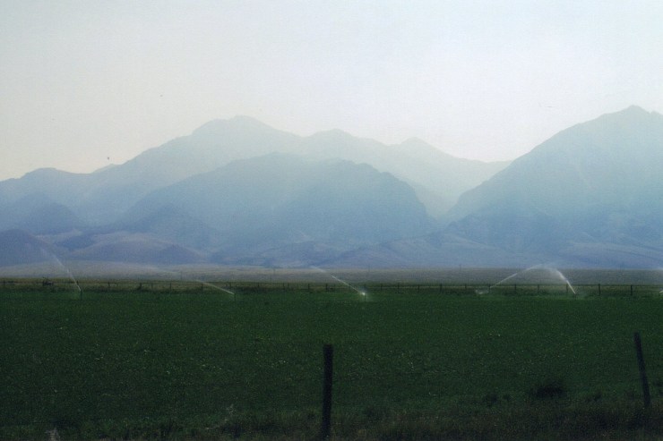
On the morning of July 24th, I found myself in Blackfoot, Idaho on the edge of the Fort Hall Indian Reservation. The plan for this day was to simply work my way north to Mount Borah, find the trailhead and get in a short acclimatization hike on her lower slopes. The trailhead proved quite easy to find with a well-marked gravel road leading four miles from Route 93. I hiked in and upwards for less than a mile (gaining about 800 feet) and left feeling pretty good about my chances of summiting the next day. Chicken-Out-Ridge, however, loomed large in my mind the rest of the day as I tried to keep my self doubts in check. I’ve never been shy about turning around on a mountain when things don’t feel right, but I really didn’t want to “chicken out” in good weather while feeling physically fine. In short, I didn’t want to lose a mental battle with this peak.
After a restful night at Challis Hot Springs, I arrived back at the trailhead rarin’ to go at 6 AM the next morning. There were already several cars in the hiker parking lot with an assortment of prepared-looking and unprepared-looking climbers milling about. This contrasted sharply with the mere three cars that had been in the lot the previous day. Basically, even though I was soloing, I knew I’d have plenty of company for this one.
Within just a few minutes of arriving, I set off down the trail. I fell quickly into a steady pace and tried to keep my speed in check. I most definitely didn’t want to burn myself out down low and have nothing left for up high. Slow and steady wins the race. I expected to be passed but instead passed a twosome less than a mile into the hike. Then I passed a father and a daughter a short time later. “Damn, I’m moving too fast,” I thought to myself. But I felt strong as I moved upslope putting 2,000 feet under me in a little over an hour. Once I hit tree-line, the scenery opened up but the unmarked trail remained challenging. My pace slowed some but I steadily gained ground on a couple of hikers. Not a cloud in the sky and the temperature felt warm even at this early hour and elevation.


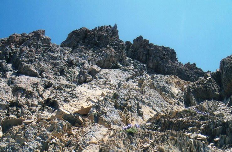
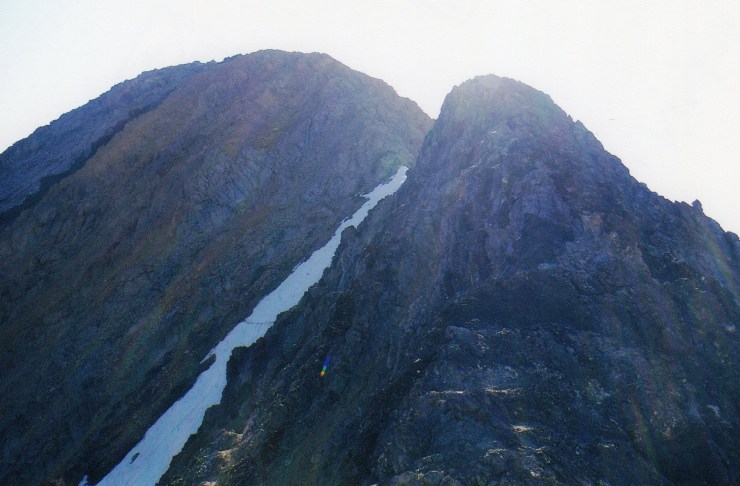
I enjoyed every minute of the hike as I closed in on Chicken-Out-Ridge. Now that I was in motion, my self-doubts melted away. “Stay high on the ridge … right over the top.” That’s what I’d read. “The handholds are good and the rock is solid.” Just before reaching C.O.R., I caught up to a couple from Idaho probably in their late 20s or early 30s. I took an instant liking to them and we talked a bit. I soon learned that the gentleman had previously climbed Borah and he helped kill any remaining doubts I had about Chicken-Out-Ridge. Before long, we were all scrambling over the Class 3 terrain closing in on the snowfield at the end of the ridge. The crossing of the snowfield proved easy as solid steps had been kicked in by this season’s climbers.
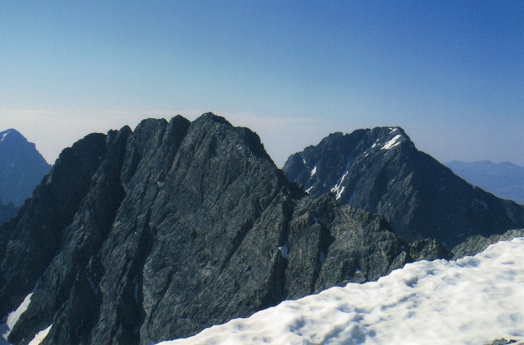
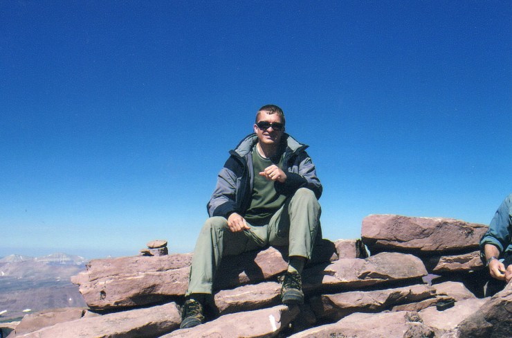
The most difficult portion of the terrain was now behind me and the trail flattened out for a bit leading up to the final 800-foot grunt up the scree and talus slope to the roof of Idaho. The young couple and I leap-frogged past each other a few times and we all reached the summit within a few minutes of each other right around 11 AM. I felt so good about reaching this summit! The views were incredible and the USGS summit marker with Mount Borah’s original name summed it up perfectly … “Beauty.” It was my 42nd highpoint and undoubtedly my favorite. The Lost River Range is rugged and spectacular – the way mountains are supposed to be. I would love to go back there someday.

And if they ever stumble upon this, thanks to Chris and his girlfriend for taking my picture on the summit. I’m glad I was able to return the favor.
The hike out was uneventful and I was back at the trailhead by 2:45 PM with a successful trip now assured no matter what surprises Utah might have in store.
Kings Peak, Utah – High Uintas Range
My first impression upon reaching the outskirts of the Uintas Mountains early in the afternoon of July 26th was one of instant intimidation. I’d read about the severe weather that the range had to offer in the summer months and watched from the safety of my rental car as a grey mass of clouds moved in over the peaks. My plan for today was just to familiarize myself with how to get to the Henry’s Fork trailhead and then spend the following day and a half renourishing my sore legs from the Borah climb. After I passed Evanston, Wyoming, the weather deteriorated steadily and I was soon watching a full-fledged lights show as the range got pounded by the elements. Continuing through Mountain View, Wyoming to a series of Forest Service roads, I watched a steady stream of vehicles driving away from the direction of the trailhead. Before I knew it, the dirt road had a coat of ice on it, no doubt the result of a hailstorm I had just missed. Thank God I hadn’t chosen to climb Kings Peak before Borah as this would have been my scheduled summit day! Enough of this, I thought, as I turned back for Evanston and the cushy accommodations of a Motel 6.
For the rest of the day and all day on Sunday, I obsessed over the weather and prepared for the worst. The weather pattern over the last several days had not been encouraging and I knew there was a chance the climb might not happen. But as the day progressed on Sunday, I had reason to be hopeful as the atmosphere seemed to stabilize and the predictions of thunderstorms dropped significantly. Que sera sera, I decided.
I set off from the Henry’s Fork trailhead at 9 AM Monday morning under gloriously blue skies. Little did I know that these blue skies would be the norm for the next three days as I began down the trail feeling completely refreshed from my stay in Evanston. I started my hike early with the thought that I would like to get in my 7.5 or so miles of hiking before the heat rolled in and wanted my campsite set up before thunderstorms threatened.
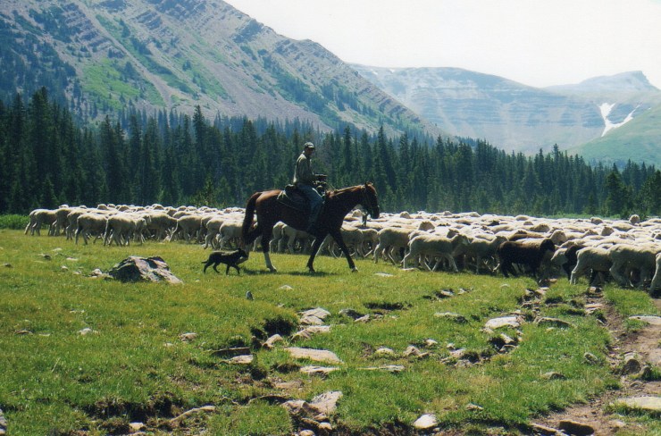


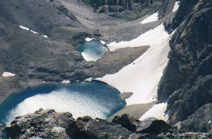
The hike in to Dollar Lake was astonishingly pleasant and the vertical gain of only 1,400 feet over this stretch gave my legs no trouble. Add in some friendly hikers, an unexpected encounter with a herd of sheep and terrain that opened up magnificently after Elkhorn Crossing and you have about a perfect day. I was the first to set up camp at Dollar Lake on this Monday afternoon and my first excursion to the lakeshore brought with it and encounter with three moose quenching their thirsts. Unfortunately, I had left my camera back at the tent and missed the shot. I spent the rest of the day gazing at the mountains with Kings Peak visible in the distance. I drank plenty of water and was somewhat surprised at how “normal” this lowlander felt at nearly 11,000 feet.


At 6 AM on Tuesday after a fitful night’s sleep, I strapped on my pack under clear skies with a climb to the zenith of Utah being the goal for the day. As I closed in on the slope leading up to Gunsight Pass, I couldn’t really tell what the trail was going to do and it looked to me like it would scramble up the slope to near the 12,000 foot mark before a slight descent I knew awaited me on the other side of the Pass. I’d done some research on the “shortcuts” and none seemed to appeal to me. I had all day to cover the 14-mile round-trip and I was less than convinced that any of the shortcuts would save any time and would certainly be more work.
Anyway, the route to Gunsight soon became evident – a wide, sweeping switchback … Class 1 all the way and fairly mellow. Within an hour of leaving my tent, I reached Gunsight Pass and felt good. In spite of my plans not to take any shortcuts, I soon spied one that way too good to pass up as I descended toward Painter Basin. The trail essentially split … straight ahead was the “long way,” but to the right, the path paralleled the well-known yellow cliff band just below any kind of awkward scree traverse. I quickly zoomed by a pair of climbers that had taken a higher line and were making slow work of the blocky scree field. Toward the end of the shortcut, I had to make my way across a couple of minor snowfields before ascending back up to the main trail.


My pace now started to slow a good bit and I stopped for regular breaks as I climbed through the contours above 12,000 towards Anderson Pass. An occasional backward glance revealed the twosome that I’d earlier passed was slowly gaining on me. By the time I reached the Pass and stopped to take a few pictures, the three of us were together and talked a bit. Easterners all three as it turned out. They hailed from New Jersey and both had dabbled with some of the 7 summits including Denali – which was of interest to me as a State Highpointer. And I, of course, call New York home.


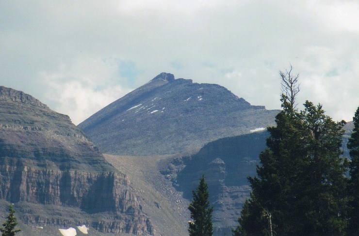
From Anderson Pass, the route steepened significantly. The final 6/10 of a mile with 1,000 feet of elevation gain no longer qualified as a regular “hike.” At first I lead as the three of us worked our way up the Class 2 scree slope but clearly the gentlemen from New Jersey were itching to pass me and did so as I stepped aside to put my hiking poles in my pack. Progressively, the route became sketchier and care had to be taken to avoid sheer drop off of several hundred feet to the right. To the left, the slope was much more manageable and I made sure I stayed well below the ridge. Finally, perhaps a few minutes before 11 AM, I put the last of several minor false summits behind me and the summit block lay just ahead. Within minutes, I emerged onto the summit area and stomped on the highest point as my first order of business!


A half an hour or so of pleasant conversation and photo-taking ensued with the folks from New Jersey as well as two more climbers from Utah who summited as part of a five-day backpacking trip. The five of us comprised the “early” summit crew and as I descended, I was glad to have started at dawn as hordes of other hikers worked their way upwards on this cloudless day.


By 3:30 PM, I was back at my tentsite – plenty of time I to pack out if I had so chosen. But I had no reason to hurry. My flight back to New York wasn’t for another day and a half and I was thoroughly enjoying my stay in the backcountry … so I collapsed into my tent and made the most of the peaceful scenery. The following morning, I broke camp completely satisfied with this trip and now seven tough western highpoints away from completing my goal.
