So this smaller adventure started much in the same way that many of my other outdoors travels have begun in recent years. Specifically, state highpointing. It always seems to cycle back to state highpointing for me. Even though I completed my 50th state highpoint in 2015 and took a but of a victory tour in 2016, a love of this list of major US peaks, mid-range mountains, minor hills, and just off-the-beaten-path geographical oddities continues to burn brightly within me.
In early 2019, I found myself preparing for a planned June trip to California to attempt Mount San Antonio and Mount Shasta (fake state highpoints in their own right under the #Cal3 initiative) when an interesting news article popped up on my twitter feed. A local state Senator was proposing a study to divide New York into two separate states, essentially reflecting and reinforcing the well-known cultural and political differences between upstate and downstate NY. Under the proposal, the downstate version of New York would include Nassau, Suffolk, Rockland and Westchester Counties as well as New York City. Given that the upstate version would contain current state highpoint Mount Marcy, I immediately went to work to determine the location of the highest point of the downstate version. The “new” state highpoint if you will.

The search quickly took me to Rockland County in the heart of the Hudson Highlands, which is home of West Point and steeped in Revolutionary War history. What better place to go looking for a new state highpoint than in one of the very battlegrounds that led to the formation of this great nation?!? I looked over some online topographical maps and started to zero in on a specific cluster of peaks before checking out peakbagger.com, which is recognized as an authority on such matters within the outdoors community.
And this is where it gets just the tiniest bit complicated. Peakbagger.com lists two different Rockland County mountains as co-highpoints. Rockhouse Mountain has a summit elevation of 1,283 feet while Jackie Jones Mountain comes in at 1,280 feet. But here’s the kicker. While the elevation of Rockhouse is an exact measurement, the elevation of Jackie Jones is derived from its highest contour. This is a fairly regular thing that peakbaggers like myself encounter. Given that the contours are 20 feet apart on maps for the area, this means that the actual “true” summit elevation of Jackie Jones Mountain lies somewhere between 1,280 and 1,300 feet. Another authority on such matters (ListsofJohn.com) splits the difference and assigns an elevation of 1,290 feet to Jackie Jones Mountain and gives it status as the Rockland County highpoint. Meanwhile, most peakbagger.com users gravitate toward recognizing Rockhouse Mountain as the highest point.

So the answer was clear. I’d just have to hike them both. What follows is my story of the ascents of these minor mountains as well as four other hikes I completed in the Hudson Highlands during the late winter and spring of 2019 while training for my much bigger California agenda.
Jackie Jones Mountain – March 8, 2019
I have to admit I was more excited about this little project than the heights of the involved mountains should have warranted. Although I’ve lived in New York State my entire life and have always been aware of the Hudson Highlands, I’ve never taken the time to explore them on foot. The higher peaks of the Adirondacks and Catskills have always called out to me … but now after nearly 50 years of NY living, the Hudson Highlands finally had my full attention.
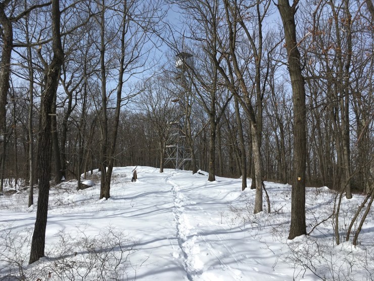
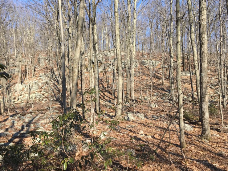
So on a bright, sunny late winter morning after dropping my daughter off at high school, I drove two hours south and then east, exiting the Palisades Parkway and working my way to Kanawauke Road in Stony Point, NY not far from Lake Welch and just inside the boundaries of Harriman State Park. Upon arriving at the trailhead, it was quite chilly with a blanket of about six inches of mostly fresh snow that had fallen just a few days earlier. So I bundled up for a 4.5-mile loop hike I’d researched that would take me to the summit of Jackie Jones Mountain as well as the nearby Big Hill.
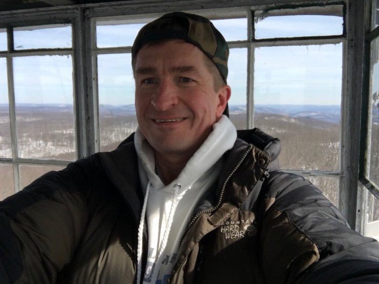
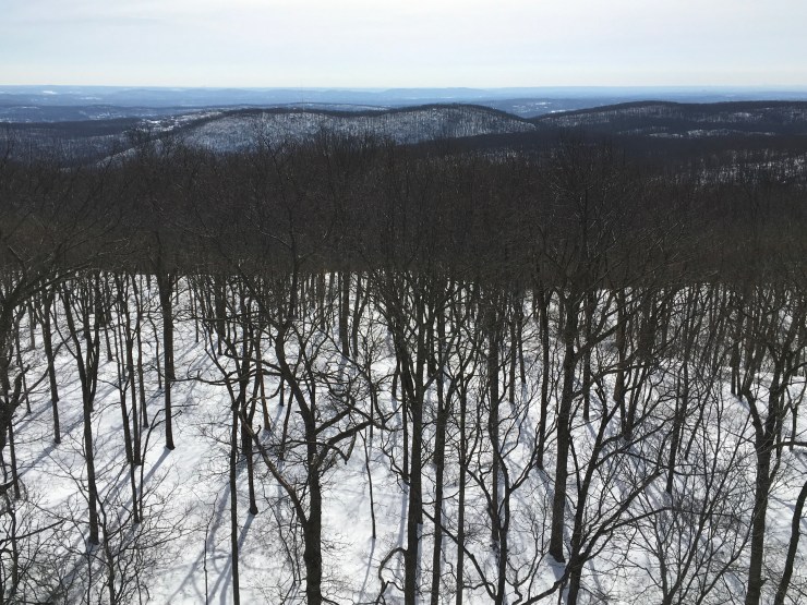
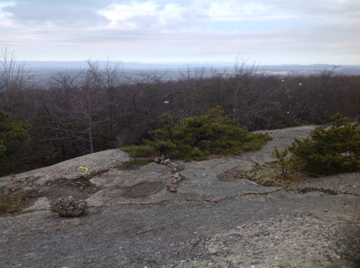
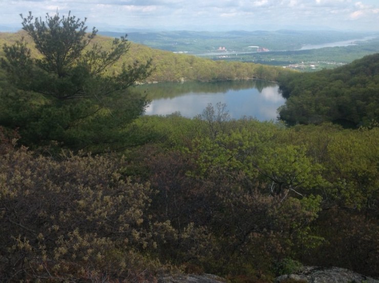
Had I just been interested in tagging the fire tower atop Jackie Jones Mountain, there is an option to walk a paved road that leads there in about a mile. Instead, I hopped on the Suffern-Bear Mountain Trail and passed through the Orak Ruins before working my way towards the Jackie Jones summit. I stopped to take a good number of photos but lost all but four of them due to an iPad glitch a couple of weeks later. Anyway, after less than an hour of playing in the snow, the newly restored fire tower atop Jackie Jones Mountain came into sight. Just a few minutes later, I climbed to the cabin atop the tower and enjoying sweeping views of the Hudson Highlands on a very clear day.
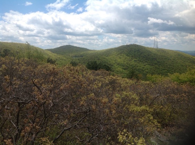
From here, it got a little trickier. I spoke briefly with a nice young couple (the only other people I encountered on this day) before resuming my trek towards Big Hill. Whereas the snow-covered trail to the summit of Jackie Jones had been broken out by a few other hikers since the snowfall, there were no signs of recent foot traffic leading towards Big Hill. So it was now up to me to break trail while paying close attention to the terrain and trail markers. I embraced the added challenge for another mile or so before finally reaching the well broken-out “Old Turnpike” and Long Path that took me to the top of Big Hill. Towards the top, I took a left instead of a right at one junction, but instead of backtracking I decided to correct the error by going off trail up a rocky slope that led to my second minor summit of the day, where I took in some more lovely views.

The descent/loop completion was simply a matter of quiet walk in the snowy woods, stopping along the way to enjoy some lunch while relaxing on a trailside boulder.
Rockhouse Mountain – March 20, 2019
Less than two weeks later, I was back on the first day of spring. The route to this peak starts just a few miles down the road from Jackie Jones Mountain and I actually passed that trailhead on my way to this hike, starting on the opposite side of Lake Welch along County Route 106 (AKA Kanawauke Road). Like my hike from just 12 days earlier, it was again bright and sunny, but unlike that day, it was in the 50s and all of the snow had melted away.
For Rockhouse Mountain, I had picked out a loop hike of about 3.7 miles that follows some lightly-to-moderately used trails and also includes a short bushwhack of a few hundred yards to the summit of Rockhouse. I hadn’t entirely anticipated just how lightly some of these trails would be, but in the end, it only added to the fun.
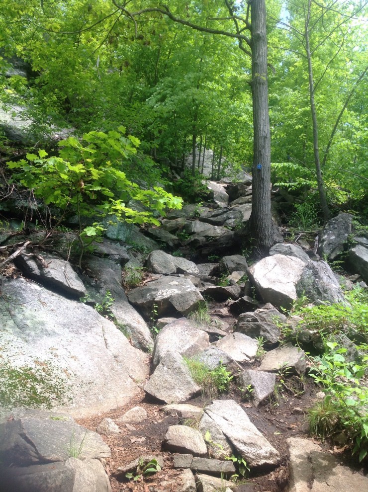
Starting from CR-106 at an unmarked and very easy-to-miss parking area, I started to hike along the blue marked Beech Trail that runs along the east shoulder of Rockhouse Mountain. Just as I had 12 days earlier, I took ample photos, again losing all but four to the universe when my iPad broke that very night. If I hadn’t posted the four pictures on twitter later that afternoon, they’d all be gone. In any event, the Beech Trail was pretty easy to follow and the summit ridge of Rockhouse became apparent after a mile or so of hiking. I stuck to the trail until I reached the point where it started to descend and then broke off-trail for the start of my bushwhack. Spring is a great time for bushwhacking and has always been my preference when engaging in this activity as the woods tend to be very open and it’s easy to pick out terrain features. This same bushwhack in late summer would be not-so-fun, IMO, since the undergrowth would be thick and seasonal foliage would obstruct views.
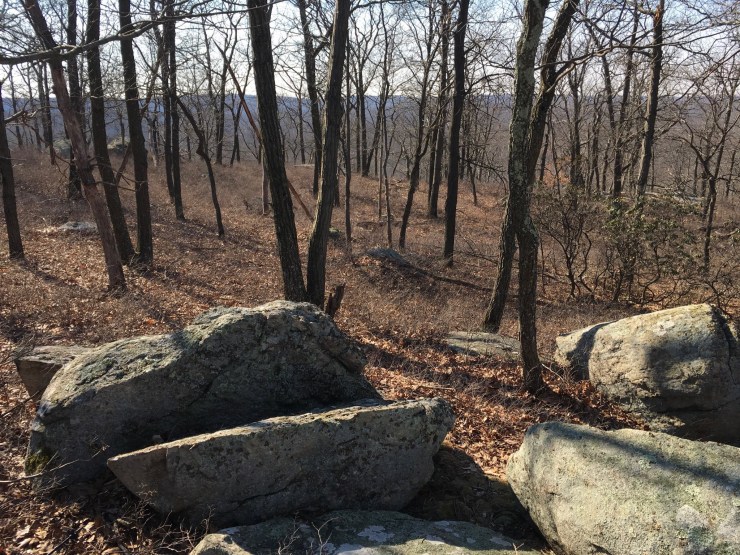
I had read on peakbagger.com that there is a large cluster of boulders on the true summit and after following the entire ridge from north back to the south, I found myself agreeing with this assessment. I hit every minor bump along the ridge as I tend to do, but the tippy top seemed pretty obvious. After snapping a few more pics, I worked my way back to the trail for the completion of my loop hike.

Shortly after rejoining the blue marked Beech Trail and heading north, I spotted a red marked trail on the left. The idea for me was to basically circumnavigate Rockhouse Mountain. So with the summit ridge now to my south, I started heading west towards Lakes Askoti and Skannatati on the far side of the mountain. After a half of a mile or so, I intersected a north/south trail and turned left again. Honestly, I don’t remember the name or the color of the trail but I’m not sure it matters because it was more of a non-trail and I soon found myself bushwhacking once again while following a generally SSW bearing. I kept the mass of Rockhouse Mountain to my left and the just-out-of-view twin lakes to my right (you could tell where they were even though you couldn’t actually see them) until I eventually intersected a power line cut, which quickly took me to the Long Path. From here, it was pretty easy. The Long Path took me across CR-106 and eventually met up with the Beech Trail, which I then followed north to complete my loop.
Once again, a very fun half day of exploring in the Hudson Highlands.
Schunnemunk Mountain – March 25, 2019
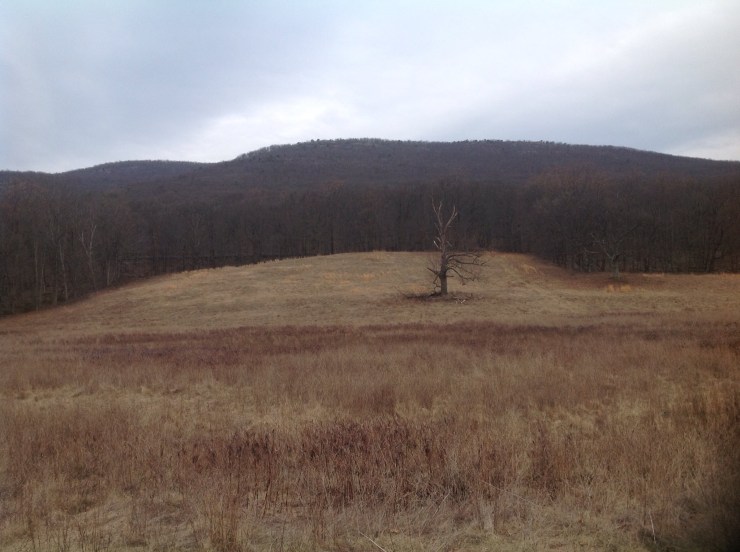
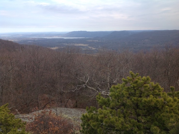
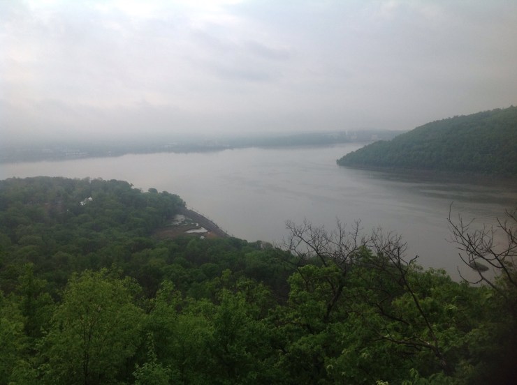
Only five days after my Rockhouse Mountain hike, I found myself southbound on the NYS Thruway once again, this time bound for Mountainville, NY and the start of a somewhat more aggressive day-hike on Schunnemunk Mountain. At 1,664 feet above sea level, Schunnemunk boasts the highest point in Orange County and – at least according to some – is also the highest point in the Hudson Highlands. Other folks award that distinction to South Beacon Mountain, which is slightly lower but is a more geologically natural part of the Highlands.
My itinerary for this hike involved an eight mile out and back with about 1,400 feet in elevation gain and loss for the day, starting in a farmers field very close to the NYS Thruway between Exits 16 and 17. The parking lot was large and maps were provided at the trailhead indicating this is quite a popular hike … although not so much on a weekday in late March. I would see a few other hikers and dog walkers during my hike out later in the day but was on my own for most of it.
I started off along the Jessup Trail in somewhat mucky conditions across the aforementioned farmers field before reaching the junction with the Sweet Clover Trail after about 10 minutes. From there, another meadow beckoned that took me within 100 or so feet of the Thruway before abruptly swinging away from it and heading uphill. It was then a steady upwards hike that was never overly aggressive but did most definitely get the blood pumping. In keeping with the mass transportation theme of the early part of the day, the trail soon crossed a very active train track with an Amtrak train having made its way through the area while I was still down very low.
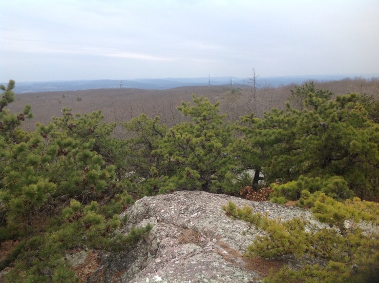
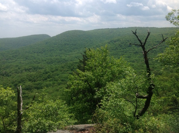
Given the fairly straight uphill nature of this hike, views to the east were most outstanding and everything felt very open in the early spring conditions (no foliage). After about an hour or so, the summit ridge was attained, with a left turn then leading back along the yellow/teal-marked Jessup Trail for a very long ridge walk. Just as on Rockhouse, I hit pretty much every bump along a ridge that went on and on for about two miles. A few flurries and a rumble or two of thunder added a bit of an ominous feel to the trek. When I finally found myself looking down at some nearby radio towers after about an hour of ridge walking, I was confident I’d covered its entire length and called it good.
It wasn’t until I got home later and checked out peakbagger.com that I became sure which point along the ridge was the highest. During my hike, I had seen two areas of barely legible paint on the rocks where a fire tower had once stood. One of these announced “Site of Firetower” while “1664” was written in the other area just about 10 yards away. At the time, it didn’t dawn on me that 1,664 is the summit elevation of Schunnemunk Mountain. Mystery solved.

A solid little hike, for sure.
South Beacon Mountain and Scofield Ridge – May 16, 2019
It would be nearly two months before I returned to the Hudson Highlands. When I arrived at the South Beacon Mountain trailhead on Route 9D in the middle of the village of Beacon in mid-May, spring had firmly taken its hold on the lower Hudson Valley. I was blessed with a bright and sunny day with forecasted high temperatures somewhere in the 80 degree range. Unlike my earlier Hudson Highlands hikes though, I was most definitely no longer thinking about the proposed division of New York into two different entities. Instead I was looking ahead to my planned hiking/climbing trip to California, where I would be attempting Mount San Antonio and Mount Shasta beginning in just three weeks. With that in mind, I was looking for an aggressive training agenda that would help increase mountain fitness.
The hike I chose was a rolling eight mile loop hike with over 2,000 feet of elevation gain. Not bad considering that the highest elevation attained during the hike is the 1,611-foot summit of South Beacon Mountain, which many consider to be the true geological highpoint of the Hudson Highlands despite being more than 50 feet lower than Schunnemunk. My agenda would follow a series of trails including the Casino Trail, the Wilkinson Memorial Trail and the Fishkill Ridge Trail, first over the summit of South Beacon Mountain, then over three minor bumps along Scofield Ridge and eventually to the top of Lambs Hill before beginning the descent and closing the loop.
In the end, it was a fantastic day of hiking; exactly the kind of day out I had wanted. Just a few quick bullet points/fun facts and I’ll let the pictures do the rest of the talking.
The hike starts at the base of the Mount Beacon Incline Railway, which operated from 1902 to 1975 and was reportedly not only the steepest railway in the world but also the inspiration for the famous children’s story “The Little Engine That Could.” The remnants of both the track and engine house are still in place with some ruins being reached along the Casino Trail after the first mile of the hike, which gains a stiff 1,000 feet in elevation.
Secondly, Scofield Ridge is listed on peakbagger.com as the highest point in Putnam County because – as I said – it always circles back to highpointing for me. The slightly more lofty South Beacon Mountain is in Dutchess County, the high point of which is the 2,323-foot Brace Mountain in the South Taconic Range to the north.
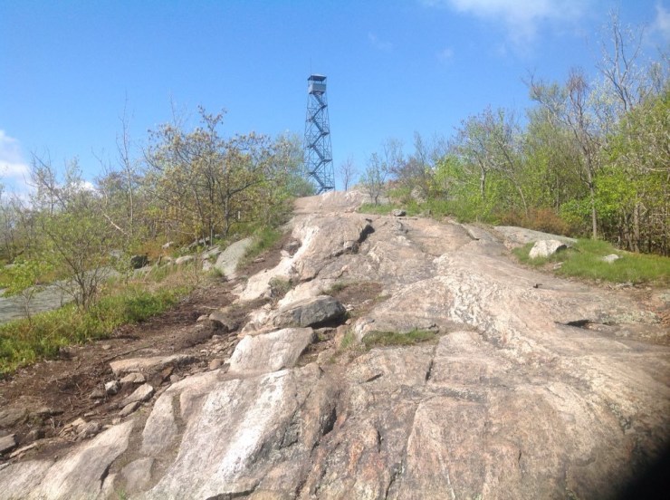
And lastly, I chose not to climb up the fire tower atop South Beacon on this day. Upon reaching the summit, I noted a young couple up in the cabin of the tower and let them be while I enjoyed my lunch on the open rocks while taking in some magnificent views.
Another fun day in the Hudson Highlands.
Anthony’s Nose and Bear Mountain – May 20, 2019
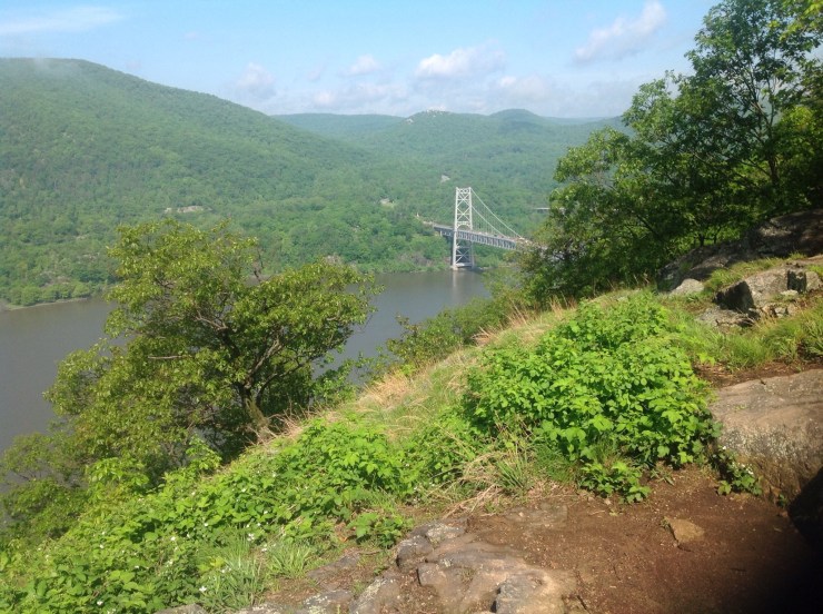
Just four days later, I was back in the Hudson Highlands for what I planned to be my last training hike before my California trip. This time the goal was to up the ante even more. My last Hudson Highlands hike had featured more than 2,000 feet of elevation gain; on this day, I put together an agenda that took in close to 3,000 feet of gain. The plan was to take the long approach to Anthony’s Nose in the morning and then head to the opposite bank of the Hudson for a hike of Bear Mountain in the afternoon.
Over the last couple of years, I have developed a new personal mantra: “the adventure you plan is never the adventure you have.” This phrase popped into my head early that morning as my vehicle GPS led me slightly astray. I had programmed the GPS with what I thought was good information for the start of my hike at the Bear Mountain Bridge Toll House, from which the Camp Smith Trail would take me over several rolling hills to top of Anthony’s Nose. Instead I found myself parked a boat launch at a traffic circle in full-blown Westchester County AM rush hour traffic. Hmmmm.
So I pulled out my paper maps and scanned the terrain before deciding which way to go. In a nutshell, I decided to go “thataway,” which turned out to be the right call as I soon passed the entrance to Camp Smith and then spotted the old tollhouse, which I recognized from pictures I’d seen online. Once on the trail, I was in an all-business kind of mood as I followed the blue-blazed trail, which led me relentlessly up and down (steeply at times) over many little and not-so-little bumps until I reached Anthony’s Nose after about 3.5 miles of hiking. When one figures in the return trip, which once again goes over all those same bumps, the elevation gain total for my AM hike came in somewhere around 1,700 to 1,800 feet. An excellent start to the day.

Wasting no time, I pulled up my saved addresses on my GPS for the starting point of my Bear Mountain hike and was promptly led astray once again. This time it wasn’t really even close with my usually trustworthy GPS leading me to a spot a good four miles from my Bear Mountain Inn starting point. Slightly annoyed, I pulled up a second saved address that brought me much closer to the Inn but was still wrong. How tough can this be, I thought? Bear Mountain is quite probably the single most popular hike in the Hudson Highlands and is within a state park. So I decided to just open my eyes and pay attention to the road signs. No more than 5 minutes later I was at the starting point of my hike.
The four mile loop hike I planned would start along a paved path on the shore of Hessian Lake, the site of a bloody October 1777 Revolutionary War battle where the outmanned American Patriots prevailed and which is said to be haunted to this day by the 250 Hessians who lay at the bottom. From there, my route would swing up the Major Welch Trail and climb steeply 1,100 feet to the top of this very popular mountain, crossing the summit road along the way. Closing the loop would be a matter of descending down a newly reworked section of the Appalachian Trail back to my starting point.
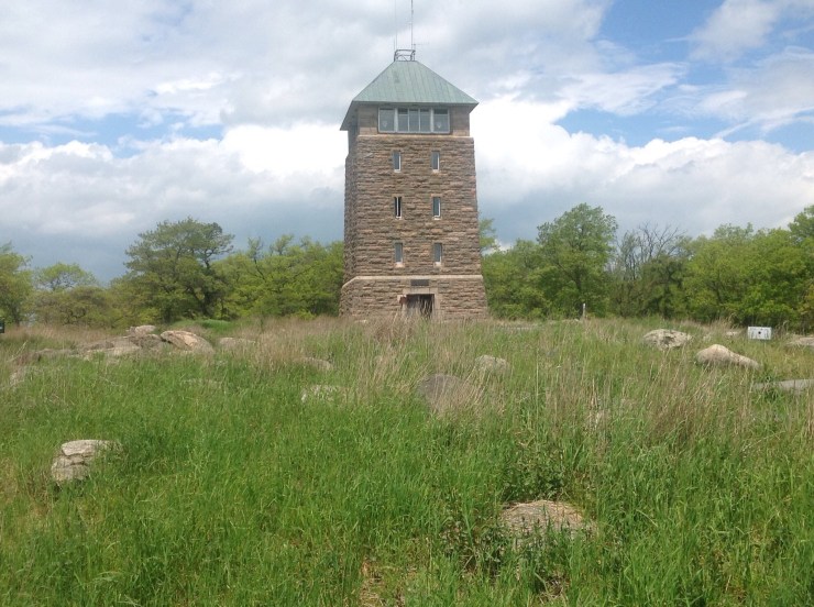
Once I was finally out of the car and on my way, finding my way was pretty easy. One fit-looking hiker dude sized me up as bound for the Major Welch Trail and warned me of one area where he had lost the trail … an error that cost him about a half an hour. Other than that, I would see no one else during my ascent of the Major Welch Trail. This, of course, changed when I got to the large parking area atop Bear Mountain where picnickers and selfie-takers could now be seen in every direction on this beautiful afternoon. I spent a few minutes in the Perkins Memorial Tower on the summit after checking out a nearby rocky area where it looked like a fire tower had once stood. Tough to say which was the true high point. In any event, after spending about 30 minutes on top, I started making my way down the Appalachian Trail, where I encountered dozens of other hikers still making their way upwards. Some looked happier than others.


Two great hikes on this fine day. Legs and lungs felt great and I was feeling as ready as I could expect to be for my big California trip.
