Introduction
The year was 2020 and we were all faced with the same grim reality. As the COVID-19 pandemic sent the world into lockdown, questions of what we could actually still do and how we could go about doing it stared each of us in the face. Stay Home, Save Lives, Lose Sanity. Or something like that.
The outdoors called out to me like they always do. Solo hiking in obscure places seemed like an OK and socially-responsible thing to do regardless of government mandates restricting the crossing of state lines. Drive straight from home to the trailhead and stop only for gas as required. Have mask, will travel.

Vermont County Highpoints
It all started innocently enough with Vermont County highpoints. Well-known outdoorsman Stony Burk had suggested this project for me at some point along the way. I had mentally dismissed it initially as I’m not a county highpointer, but times were different now. A review of peakbagger.com revealed that I’d already visited the summits of nine of the 14 counties in the Green Mountain State. So a list of just five. A pretty minor project but one that included a couple of bushwhacks as well as some other rarely visited summits. Just what Doctor Fauci ordered.
Windsor County zenith Gillespie Peak would be first up. Not an easy task as I quickly found out. On April 25th, I made my first attempt reaching intermediate bumps Mount Horrid and Cape Lookoff Mountain before losing the way in lingering early spring snow. I hadn’t come equipped for a battle so decided to leave it for another day. Less than a month later, I was back, this time reaching the summit of Gillespie via a pretty rugged and lightly-used trail on May 20th. OK, now, we’re rolling.

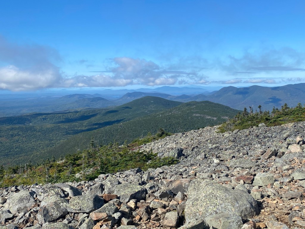
Just nine days later, Essex County highpoint East Mountain in Vermont’s Northeast Kingdom would be my target. A pleasant hike along an abandoned paved road to a dilapidated radar station bumped my Vermont CHP total to 11 of 14.

Time to get serious. The key obstacles to a Vermont CHP completion are Orange and Caledonia County highpoints Butterfield and Signal Mountains. Each can be reached only after thick bushwhacks located very close to one another along the same dirt road that straddles the county line. July 2nd would be my chosen day for this challenge and my twin whacks couldn’t have gone any more smoothly as I reached my lucky numbers 12 and 13.


This left only Grand Isle County, Vermont’s only non-mountainous county. On July 14th, I first investigated an area on the north part of the county inside a 270 foot contour before heading to Snow Farm Vineyard in South Hero where I first purchased 12 bottles of wine and obtained permission to hike to the unmarked 279 foot high “summit” of their privately owned hill.
Sweet success.

Northeast 2,000 Foot Prominence Peaks
And this is where the story takes an unexpected turn.
The pandemic was now in full swing with no end in sight. Ultimately, it would be close to another two years before things started to get back to a full sense of normalcy. Air travel was out of the question and the cruise industry was suffering some massive losses in the face of floating COVID sick ships that were not even allowed to dock.
While researching and completing those final five Vermont county highpoints, I saw that both Signal and East Mountains are also included on a list of mountains known as the Northeast 2000-foot Prominence Peaks (P2Ks for short). Prominence is a different way of measuring a mountain. Instead of ordering peaks by elevation, prominence-based lists order them by how much they stand out above the surrounding landscape. In the contiiguous lower 48 states, there are 57 “Ultras” that have more than 5,000 feet in topographic prominence. In the Northeastern United States, there are 55 peaks that qualify as P2Ks. Upon finishing the Vermont CHPs, a review of that list indicated that I’d done 41 of the 55 during all of my mountain travels across the decades. So 14 to go. Let’s do this!

I didn’t immediately launch into the P2K project upon finishing the Vermont county highpoints. There is, after all, more to life than hiking and there was a lot of time over the rest of the summer spent on close-to-home family fun. But once the fall hit and my mask-wearing, socially-distancing kids returned to school, the festivities would begin.

In early October, I headed to Maine to start the project in style. The Traveler loop in Baxter State Park is a New England classic. I’d read about it for years, but the Traveler had never been a part of any of my previous list-bagging pursuits.
On October 8th, 2020, I would traverse three volcanic peaks – Peak of the Ridges, The Traveler and North Traveler – over 10.6 grueling miles and 3,700 feet elevation gain with tricky footing and a 30-40 MPH cross wind. Took a full 8 hours. Game on.


From here, the Northeast P2Ks became my focal point for the next few months.
Just two weeks after completing the Traveler loop, I snuck just across the Vermont border into Bennington County on October 22nd for a beautiful fall foliage hike of Grass Mountain – a 5.2 mile round trip hike with around 1,800 total feet in elevation gain.

Mount Putnam – AKA the Worcester Range HP – much further north into Vermont near Stowe would be my next target on November 6th. The 5.4 mile round trip hike featured about 2,100 feet in elevation gain and took in Stowe Pinnacle and Hogback before getting steep and rugged towards the unmarked summit of Mount Putnam.

Just four days later on November 10th – with Northeast COVID cases remaining low – I felt a bit more daring and completed the popular 3 mile Barlow/Winslow trail loop to the top of New Hampshire’s Mount Kearsarge. I saw way more people than on any hike since early spring as we all obediently donned our masks upon seeing approaching hiker traffic.
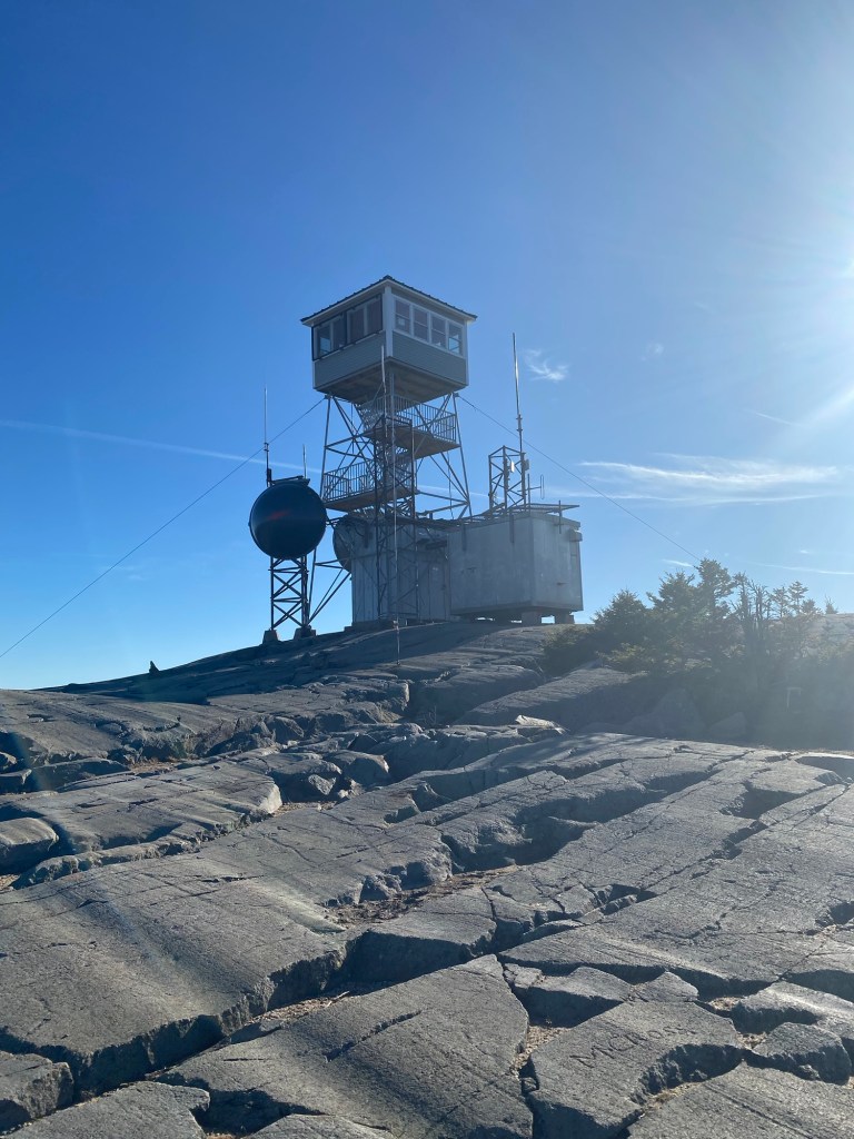
Feeling more of that New Hampshire energy, I headed back to the Granite State just over one month later on December 11th for a cold and snowy ascent of Smarts Mountain. This 6.9 mile hike along the Appalachian Trail features nearly 2,400 feet in elevation gain and boasts an outstanding fire tower on the summit that gets you well above the trees.

My bid for a NH P2K 2020 pandemic trifecta just five days later fell a bit short when I hopped on the wrong trail and hiked to the summits of Bald Knob and Turtleback Mountain rather than my intended target – Mount Shaw. It happens to the best of us.
Unfazed by the Mount Shaw misfire, I found myself back in the NH Lakes Region on January 15th for my first hike of 2021. The Mount Shaw rematch was on! This time all went according to plan and another snowy summit would be mine. About a 6 mile out-and-back with just under 2,300 feet in elevation gain. Didn’t see another soul all day.

For the next couple of months, I turned my focus to skiing, both of the downhill resort variety as well as in the form backcountry ski touring with some new skis and skins. This kept my legs in great shape so that when I finally decided to return to the Northeast P2K list and go after the highly-challenging Cold Hollow Mountains Highpoint in northern Vermont, I was ready for the challenge.
In what I will always remember as a near perfect effort, I navigated deep late winter snow and difficult route-finding to reach the 3,345 foot Cold Hollow Mountain summit right around 12:30 PM on March 11, 2021. At no point during the hike did I really think I was going to succeed, but having no specific reason to turn around, I just kept pushing until I finally emerged at the summit canister to find I’d achieved the only successful winter ascent of the year. One of my proudest mountain moments across the span of three decades of hiking and climbing.
With the Vermont and New Hampshire P2Ks now complete, my focus now shifted to northern Maine for my final seven. And what a treat it would be as many of these peaks lie in the deeply glaciated Moosehead Lake region, an area that had previously escaped my attention as I chased lists such as the Northeast 111/115 and the New England Hundred Highest. While the Moosehead Lake region mountain tops are not exceptionally lofty, glaciers carved deep cols eons ago, leading to a heavy representation in the prominence-based game I was now pursuing.
I planned for a big trip to way up yonder Maine throughout the summer months. In September 2021, I rolled into Lily Bay State Park late in the afternoon of September 15th and set up camp in the rain.
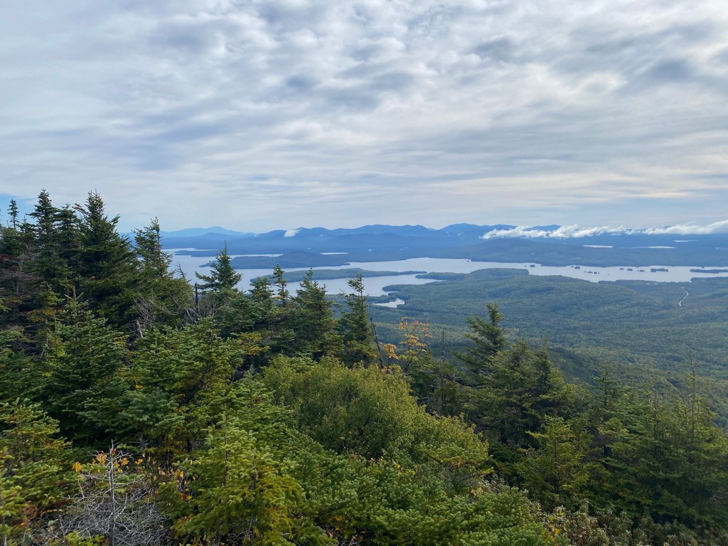
Up and out early on the 16th, I successfully executed a two summit day. In the morning, I completed a popular 4 mile round trip hike just outside of Greenville, taking in the summit of the 3,194 foot Big Moose Mountain. Although the old fire tower is no longer standing, the top of Big Moose still offered outstanding views of Moosehead Lake.
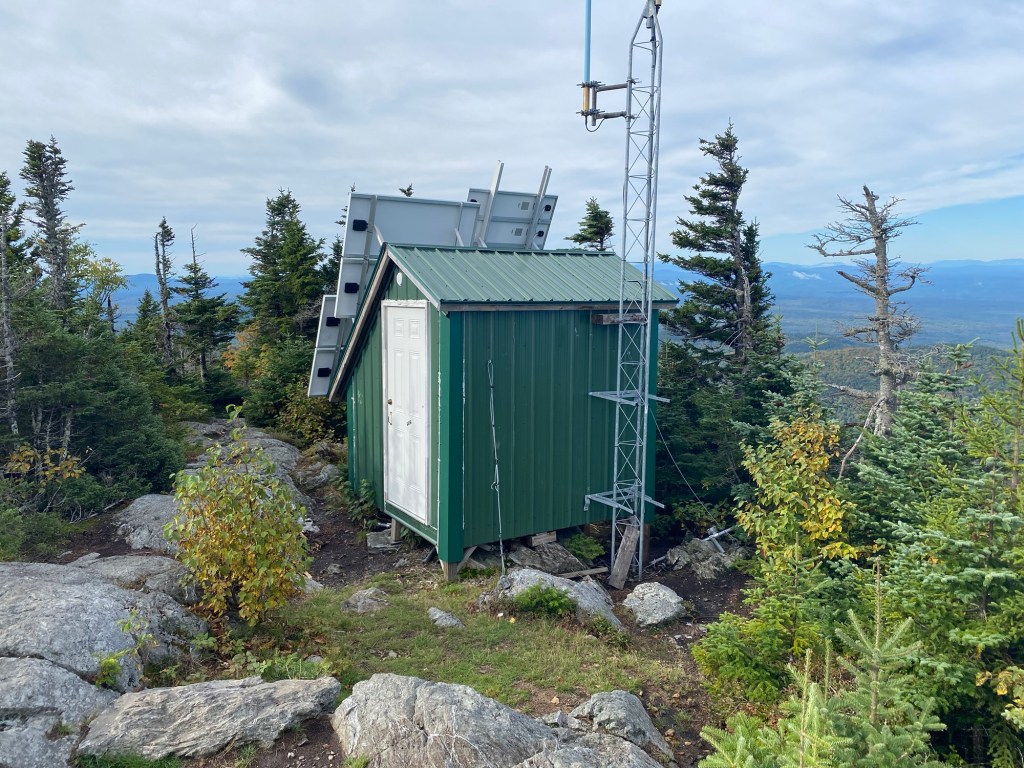
For the afternoon, my attention shifted from the popular to the obscure as I set my sights on 3,717 foot Coburn Mountain near Jackman. I located the unmarked “trailhead” after a few miles of dirt highway driving on Enchanted Mountain Road and then started up what seemed to be an old ski trail that is still used by snowmobilers during the winter. I reached an obvious clearing following a short but steep hike. From here, I located an unmarked path that led to the summit of the Northeast USA’s 21st most prominent peak after only about 1.5 of hiking from where I had parked. A solid first day’s effort.

Day two of the trip began with an adventurous 14 mile drive on the increasingly primitive Frenchtown Road as a way of accessing the famed Hundred Mile Wilderness portion of the Appalachian Trail, which would then offer fairly easy access to White Cap Mountain. Once on the trail, conditions were perfect for the 6.8 mile round trip hike with 2,100 feet of gain to the 3,644 foot summit of one of the finest mountain peaks in the region. There was more hiker traffic on this particular peak than on any of the others on this five peak trip and I enjoyed several conversations along the way.

Things ratcheted up from here. Although I’d successfully bagged three of my five targeted summits for the trip, I also knew I’d saved the toughest two for last. The 3,520 foot Baker Mountain was next up on my hit list. Baker is historically one of the more navigationally difficult of all the Northeast P2K peaks and I wasn’t quite sure what the day would hold in store for me. As it turned out, the 13 mile round trip was tough but it could have been much tougher. A recent trail cut not advertised anywhere carried me through the 9.4 mile round trip from the top of Number Four Mountain to the summit of Baker. Ultimately, I covered the 6.5 mile one way ascent from the trailhead in under 3 hours, reaching the top at 9:46 AM. A solid effort.

Now full of confidence that the trip was going to be a complete success, I pointed my Toyota Highlander towards Baxter State Park for a September 19th attempt of the spectacular Doubletop Peak. The weather gods were once again on my side for the physically challenging 9.4 mile round trip hike to the 3,488 foot summit as I finished my hiking agenda in style. The going was particularly tough in the upper reaches where class 2 terrain necessitated the use of both hands and feet. The sun had not yet warmed the wet rocks and I struggled with cold fingers during that summit push. I was somewhat surprised to encounter no one else on the trail but that had become the norm while chasing these obscure P2K peaks. I returned back to New York later that night with 53/55 P2Ks to my credit. Only Kibby and Boundary Bald remained.

For a more detailed account of my five peak trip to Maine, check out my trip report. https://marksmountaintravels.com/2021/09/27/maine-2021-solo-p2k-peakbagging/

Now for those final two. I have found that early November is a good time to visit the Maine mountains. The chill of fall is in the air but winter has not yet established its icy grip. With that in mind, I headed back north just a couple of months later with hopes of finishing up this latest pursuit on the weekend of November 13th and 14th just before starting a new position at work that I knew would limit some of my personal freedom to roam.
Kibby is near Stratton, Maine in an area rich with 4000-foot summits as well as New England Highest Hundred peaks. Over the years, I have enjoyed quite a few hiking trips to this part of the state. My agenda for this Saturday afternoon would be a fairly simple hike along the Kibby Mountain snowmobile trail approach, which leads to a nice fire tower after a pleasant 2.3 mile hike with about 1,100 feet in elevation gain. The fall weather was perfect on this day for the trip to 3,656 foot summit.

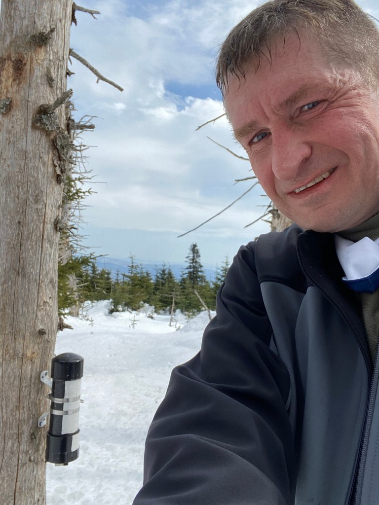
After a relaxing evening at the Stratton Motel, I got started very early the next morning for a two hour drive to the Boundary Bald trailhead near Jackman. The weather had turned cold overnight with some snow and ice adding challenge to the drive as well as changing the scenery for my final Northeast P2K. Surprisingly, I crossed paths with a couple of other hikers on this snowy Sunday morning, both of whom mentioned they were working on the New England Fifty Finest list of peaks. I had not packed crampons or microspikes so had to take a little extra care in a few icy spots during the ascent. The 2.4 mile one way hike was definitely a bit more of a push than the well-graded route I’d enjoyed on Kibby the previous day. In addition to the wintry conditions, the elevation gain was just shy of 1,800 feet for the climb to the 3,641 foot summit. No real heavy lifting but just enough of a workout to put a nice exclamation mark on the completion of my P2K project. I snapped a summit selfie at exactly 9:30 AM before hiking out and starting the long drive home.

Stay Tuned …
In a way, this all had the feeling of another chapter completed, but as I would soon find out, the whole story had not yet been told. Before long, I would hear and heed the call of the New England Fifty Finest. Stay tuned for Pandemic Era Peakbagging Part 2.
