So what’s a 50 US State Highpoint completer supposed to do?
It was many years ago in the early 90s that I read a line written by Bruce Scofield in a book about peakbagging in the Northeastern US that “the process becomes the goal” and that an inevitable feeling of “loss” usually follows the exhilaration you first feel at completing whatever list of mountains into which you have poured your soul. I’ve been through a few cycles of this over the years, but no list was as meaningful to me as my pursuit of all 50 US State Highpoints, a 22-year effort which I wrapped up on Denali in 2015 before taking a bit of a victory tour in 2016 culminating with my second ascent of Mount Rainier.
After Rainier 2.0, I kind of receded back into the world of Northeast peakbagging from which I had come, finishing the New England Hundred Highest in 2017 and then revisiting a bunch of Adirondack High Peaks (old friends, you could say) for my 2018 mountain fun.
So it was with great interest when I first read about the Cal3 initiative being bandied about in mid-2018 as a possible mid-terms ballot referendum in the Golden State. Under this plan, California was to be split up into three states … Northern California, Southern California and California. Each, of course, would have its own unique highpoint and I quickly determined that the two new state highpoints would be Mount San Antonio (California) and Mount Shasta (Northern California). Alrighty, now we’re talking. Two 5,000-foot prominence peaks to join Mount Whitney as the trio of California-based state highpoints. Seemed like just what the doctor ordered.
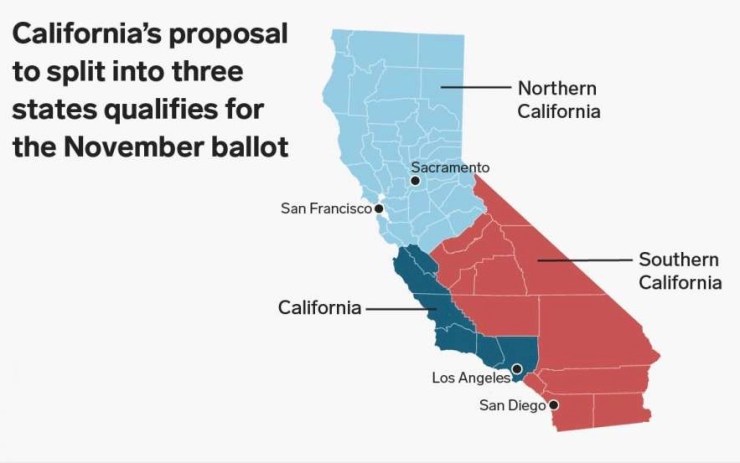
Well, of course, the initiative was thwarted at the state Supreme Court level before ever making it to the voters of California. And the gentleman who had spear-headed the entire effort chose not to challenge the Supreme Court ruling.
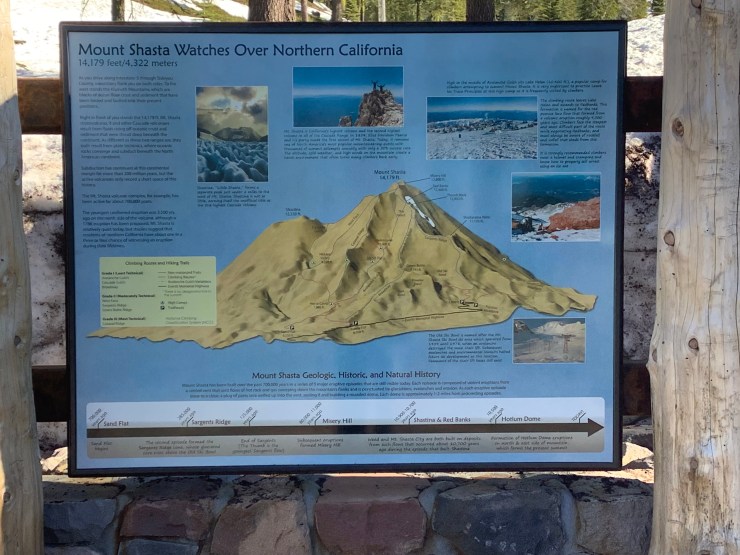
But for me, the seed was planted. I was already jazzed about the idea of returning to California for some quasi-state highpointing and reasoned that dividing California has long been a topic of discussion with many failed attempts over the years. Under almost any proposed division, Mount Shasta would become a new state highpoint including its current cultural standing as the highpoint of the State of Jefferson. Not to mention its absolute perfection as the most beautiful of all the Northwest volcanoes.

So it was on. I meticulously planned and trained this trip for close to a year before finally boarding Delta flight 2537 in the early morning hours of June 5th, 2019.
MOUNT SAN ANTONIO – JUNE 6, 2019
By the time I had secured my rental car in Los Angeles and started making my way towards the Angeles National Forest, where Mount San Antonio (AKA Mount Baldy) stands guard above the San Gabriel Mountains, it was already 2 PM, with rush hour looming. It wasn’t long before I found myself in a wall of traffic, full of nerves and repeatedly asking myself “what are you even doing?” But I was committed to making a solid effort of completing my agenda and soon the nerves began to fade as I got further from the heart of LA.
A quick stop in Burbank for supplies, food and fresh air rejuvenated me a bit before I headed back out into southern California rush hour traffic, finally arriving sometime after 6:30 PM at the Manker Flat campground at the beginning of my planned Mount San Antonio hike for the following day. Now at about 6,000 feet in elevation with my camp in order, this was beginning to feel like the mountain get-away I had conceptualized.

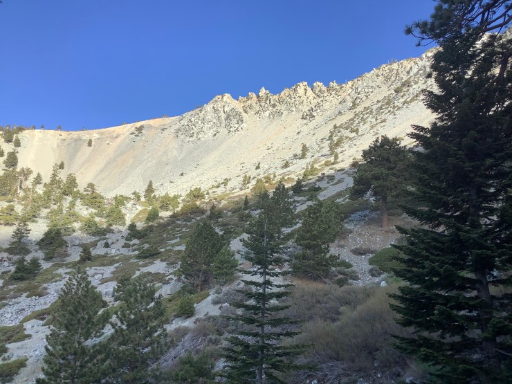
I was up with the sun on the morning of June 6th and got right down to business … or should I say pleasure as there is simply no other way to describe the Baldy Bowl – Ski Hut trail that leads 4.5 miles with 3,900 feet in elevation gain to the summit of Mount San Antonio.
Never overly aggressive but consistently steep, this trail leads at first through a pleasant pine-dominated forest before breaking into a scree and loose stone section above the Ski Hut and then finally out into the open along a ridge that offers little to no protection from the sun.


Above 9,300 feet, I started to encounter patchy sections of snow … a cool bonus for June hiking thanks to a big snow year in most parts of California. When I topped out on the 10,064-foot summit of Mount San Antonio around 9 AM, my equilibrium must have been just the slightest bit off as I became convinced that the very nearby summit of West Baldy was higher. I quickly decided it was worth my time to traverse over to the sub peak … not just for the extra bit of elevation gain and loss but also due to the realization that I would likely never be back.


The trip over to West Baldy may have been my favorite part of the morning, with snowfields and fantastic views back at Mount San Antonio dominating the way. I briefly got pulled off course by the trail that leads all the way down to Baldy Village, some 2000 vertical feet below Manker Flat, but soon corrected this error and felt my way to the sub peak. Once there, any questions as to which peak was higher were erased from my mind as Mount San Antonio was clearly the loftier summit. My altimeter watch showed an elevation difference of about 100 feet.


While I had been the first to visit the summit of Mount San Antonio on this day with complete solitude up until this point, that soon changed as three or four other hikers were atop the peak upon my return from West Baldy. I took some time to linger a bit before heading back down to the Manker Flat campground by about noontime.


Following a solid start to my California adventure and a relaxing afternoon at the campground, I slept very well during my second night at 6,000 feet in elevation, convinced that this strategy would work well for acclimatization for my upcoming climb of Mount Shasta.
MOUNT SHASTA – JUNE 9/10, 2019
Up and out early on the morning of the 7th, I began my long drive northbound through most of the state of California and arrived in the village of Mount Shasta in the late afternoon.
When I first planned the trip, it was going to be an entirely solo effort. But sometime in the early spring, I decided to throw out a feeler to my climbing buddy Boris, with whom I had summited both Denali and Rainier. I knew Boris was now living in the Bay Area of California and thought he might be up for it. The response to my email was virtually instantaneous. Boris was fully on board after a 2018 attempt of Shasta had come up a little short for him. We agreed on the standard Avalanche Gulch Route and periodically emailed each other over the next few months as we hashed out the details.
I spent most of the day on Sunday the 8th sorting gear, scouting out the Bunny Flat trailhead and eating like a horse for a little extra strength. Boris rolled into town around 3 PM and I was super glad to see him. Once again, pre-climb jitters had crept in and having my partner officially in the game helped chill me out. But still, I just wanted to get on the mountain. Once you’re actually into the attempt, all of that goes away.


Boris and I caught up with each other a bit over dinner and then turned in early. After making our way up the Everitt Memorial Highway the following morning, we hit the trail sometime around 9:30 AM with plans to hike from the Bunny Flat trailhead at 6,950 feet to Lake Helen at 10,400 feet where we would set up camp. The weather forecast for our two days on the mountain couldn’t have been more perfect. Bright sunshine and virtually windless conditions all the way up to the summit. Boris and I shared a quick laugh at the trailhead as the Forest Ranger sized us up as we headed into the woods. “I love it when folks have ice axes that look like they’ve been used. It’s the folks with shiny axes that worry me.” Being so accessible from I-5, Mount Shasta attracts a lot of traffic and a lot of attempts. Most stats I’ve seen state that only about 1/3 of summit attempts succeed.
Once in motion, any lingering jitters quickly began to melt away as we got into the heart of the matter. We had given ourselves a very reasonable goal of reaching Lake Helen within six hours, but found ourselves moving much faster. We took our first break at Horse Camp after about an hour of hiking on gentle uphill slopes with an elevation gain of about 1,000 feet from the trailhead. We then off picked another 1,000 feet of gain before taking our second break. With just 1,400 feet of gain left until Lake Helen, we talked about doing it in two 700 foot segments, but we were still feeling strong after the first 700 feet and pushed through the entire final 1,400 feet in one increasingly steep push, finally cresting at the Lake Helen campsite where tent city appeared less than four hours after we had set out. Avalanche Gulch menaced just beyond with skiers and climbers descending the steep slope in their own styles. We soaked it all in as we set up camp in the bright sunshine on a picture perfect day.


Discussion regarding our start time the following morning was the dominant theme throughout the evening as Boris and I melted snow for dinking water and prepared our dinners. As the hours went by and the matter was discussed with the on-duty NPS Ranger (whose tent was pitched nearby and who had stopped by to ensure our paperwork was in order), we settled on a 2 AM wake up call with a target departure time of 3 AM. Other strong teams in our immediate area also seemed to be settling on a 3 AM alpine start. And so it was settled.


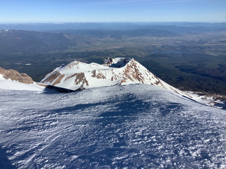
I’d like to say I awoke with the alarm at 2 AM. But the truth is that although my eyes were closed, I was already wide awake, going over the climb in my head. When Boris stirred, we both began the awkward process of fueling up and gearing up in tight quarters. By 3:10 AM, with crampons, helmets, ice axes and headlamps in place, we set off up the Avalanche Gulch. Exactly 11 minutes later, I looked at my altimeter watch and realized we had already gained 400 feet in elevation. “Must slow down,” I thought to myself, “or both of us are going to get gassed real quick.” So I slowed the pace with Boris following about 100 feet behind me. Cramponing conditions were most outstanding with a hard crunchy snow thanks to the chill of the night air. And no ice. Route finding was pretty straightforward up the Class 3 Gulch with a variety of boot tracks as well as the glow of headlamps both above and below me acting as my guides. I tried to keep us pretty much in the center of the route and we continued to make steady progress until we finally hit a zig-zagging switchback path about 2/3 of the way up the Gulch, where the angle steepens to about 35 or 40 degrees. We took full advantage of this path and soon were on the heels of a much slower moving group, who we chose not to pass, instead taking advantage of the opportunity to catch our breath a little. The skies started to brighten and the crest of the ridge got closer and closer until we hit the top of the Gulch at 12,800 feet just about exactly at sunrise. Much to our surprise, we had done all 2,300 or so vertical feet of Avalanche Gulch above Lake Helen without taking a break. We now took a long rest and warmed in the morning sun while I guzzled two liters of Gatorade. Although I was very happy with our A-plus-plus early effort, my legs were twitching a bit and I wanted to eliminate any possibility of cramping. Once leg cramps start, they are almost impossible to get rid of.


After about 30 minutes, we were back on our way with the remainder of the route to the summit split up into three small bites. First, we skirted the Red Banks on firm snow. After looking at a fairly intimidating slope during our break, the 420 feet of elevation to the plateau above the Red Banks turned out to be not so difficult after the strength regained during our break. Next was a slog up Misery Hill to 13,840′ in elevation, now putting us just a few hundred vertical feet below the summit. We took a short break here to take a few pictures as the climb to the summit lay just ahead at the end of a flat section. Such an interesting summit, which looked a bit daunting from our perch at the top of Misery Hill. We watched some folks delicately balance themselves on the rocky, airy summit and eyed the route that runs to the left of the summit mass before starting back on our way.
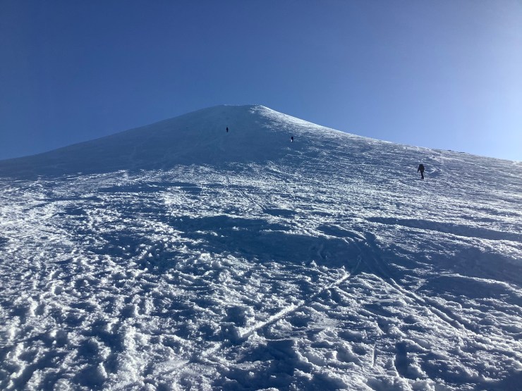


I had just started to work my way towards a notch in the rocks at the base of the final climb when I heard a woman call out “Over here. There’s a good boot pack over here.” And indeed there was … every bit as good as the switchback path we had encountered near the top of the Gulch. From here, we were on cruise control and passed a small group of 6 or 8 climbers now on their way down from the summit. As far as we could tell, they had been the first group to summit on this perfect morning. And now Boris and I would be the second. And at exactly 8:02 AM, I set foot atop Mount Shasta where I raised my ice axe triumphantly as Boris snapped a photo and then soon joined me. A nearby rock looked to be about the same height so I had my picture taken there as well before signing the summit register. What a fantastic climb it had been as Boris and I celebrated success atop our third major US mountain together. Denali in 2015, Rainier in 2016 and now Shasta in 2019.


And so it was done. The descent went the way most descents do … fun for awhile while you’re still riding that high until it eventually devolves in an exercise in drudgery. But it was all good … we had done what we came to do and regained our celebratory mood in town later that afternoon over burgers and beer.
THE WORLD ACCORDING TO ROCKY
Anyone who knows me closely knows I’m an unapologetic fan of the greatest movie series of all time … which continues to this day with the Creed franchise. It is a thread that has run the course of my entire life and I’ve used the music and training montages more times than I could ever count to motivate myself while getting in shape for my mountain adventures. I’m also not afraid to pull out a Rocky quote when the situation feels appropriate.
Just a few weeks shy of my 50th birthday, as I found myself atop Mount Shasta nearly three full years after my last “big” mountain (Rainier in 2016), the right line for the moment popped into my head. It had been uttered by an ESPN commentator at the end of “Rocky Balboa” as an aged Rocky nearly defeated fictional heavyweight champion Mason Dixon.
“They say every great fighter has one great fight left in them.”
For me, perhaps that fight was Shasta.


1 thought on “A Fake State Highpointing California Adventure Story (2019)”